What we’re proposing
To help reduce disruption and improve travel during construction, we’re considering a range of improvements designed to move more people, not just more cars:
- Smarter traffic signals and lane adjustments to help reduce travel delays around the city. This includes introducing high-occupancy vehicle lanes (T2/T3) on some of our main roads.
- Travel time messaging boards and better navigation app data.
- Support for efficient and alternative travel choices (e.g. walking, cycling, carpooling).
Tauranga has high dependency on single occupant cars, which contribute to congestion. Even a small shift to other modes of transport, such as carpooling, catching the bus, cycling, and walking will help to reduce the congestion on our roads. There is currently no funding for additional longer-term improvements, such as park and ride facilities or a more connected cycle network, but we can look at other improvements to try reducing congestion during this period of construction. These improvements may include:
Dedicated bus lanes
Lanes dedicated to the prioritisation of bus services during peak time or full time, such as the ones on Hewletts Road. Peak time bus lanes generally operate in a single direction during morning peak time, and the other direction during evening peak times. These lanes improve bus travel times and provide a more reliable service, and where a bus lane is peak time only, parking is available at all other times.
High-occupancy vehicle (HOV) lanes
High-occupancy vehicle lanes are for vehicles where two (T2), three (T3) or more people travelling in a vehicle can exclusively use the lane. This would include buses and those people carpooling, if the minimum number of occupants are in the vehicle. Due to less single occupant cars being on the road, HOV lanes assist in reducing congestion and dedicated lanes improve travel times. The use of these lanes would be enforced by CCTV monitoring.
Stopping traffic turning across oncoming traffic
To improve traffic flows on major routes, we can stop traffic from turning right across the primary traffic flows. Not only can these turns be unsafe (as the vehicle is turning in front of oncoming traffic) but they can also disrupt the primary flow of traffic on these busy routes. Not allowing right hand turns at these intersections will be safer and allow traffic to flow more freely along these routes, thereby reducing congestion. These are referred to as left in / left out intersections.
High-occupancy vehicle (HOV) Lane: Fraser Street
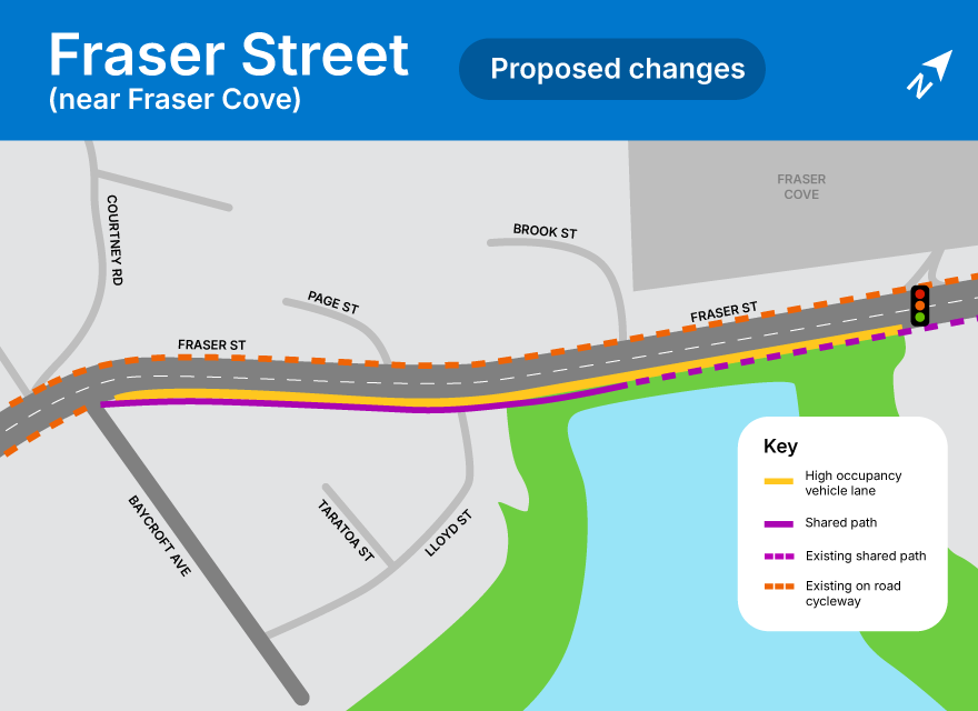
We have identified two sections of Fraser Street (southbound, away from the city toward Oropi Road) that could have an HOV lane added.
The first section would be an all-day HOV lane between Fraser Cove Shopping Centre and Baycroft Avenue (740m).

Proposed changes - Fraser Street (160kb pdf)
The potential HOV lane will start from the traffic lights at Fraser Cove Shopping Centre and end just before Baycroft Avenue. The cycle lane out of town (the same side as the high occupancy lane) will be extended with the introduction of an off-street shared path between Brook Street and Baycroft Avenue, at which point it would join back into the current on-street cycle lane. The on-street cycle lane into town will also be retained but 12 parking spaces would be removed.
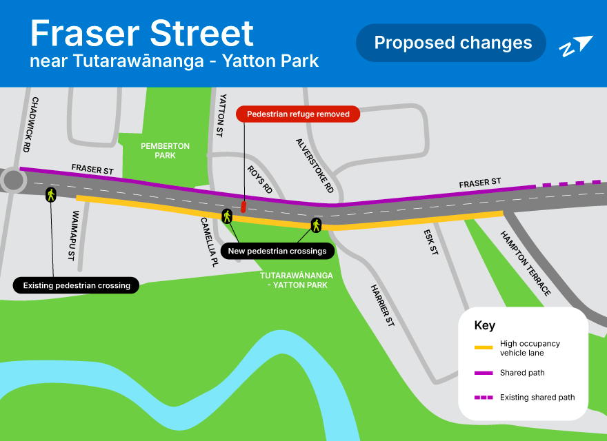
The second section would be an HOV lane between Hampton Terrace and Chadwick Road (830m).

Proposed changes - Fraser Street near Tutarawānanga - Yatton Park (230kb pdf)
The potential HOV lane will start from Hampton Terrace through to Waimapu Street (at the south end of Pemberton Park). On the other side on the road (heading into town) a shared path will be built from Chadwick Road through to Hampton Terrace, at which point it would join back into the wide footpath adjacent to the new zebra crossing, south of Kesteven Avenue. This lane could be all-day or afternoon peak only. This would result in the loss of 42 car parks on the east side of Fraser Street (heading away from town), either all day, or during the afternoon peak only.
The existing pedestrian refuge between Roys Road and Yatton Street (in front of Tutarawānanga - Yatton Park) will be removed but this will be replaced with new pedestrian crossings at either end of Tutarawānanga - Yatton Park. At the north end of the park the crossing will be located close to Harrier Street (location to be confirmed) while at the south end, the crossing will be located close to Yatton Street (location to be confirmed).
High-occupancy vehicle (HOV) lane: Welcome Bay Road
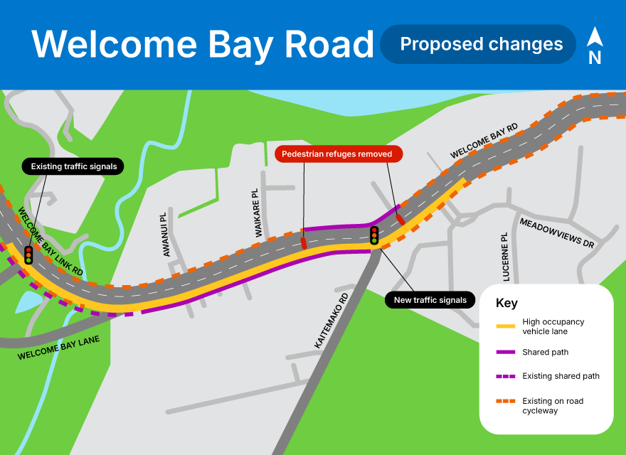
A potential all-day HOV lane on a section of Welcome Bay Road east of Meadowviews Drive through to the traffic signals near the Maungatapu underpass (westbound, towards the city). This would require changes to walking and cycling facilities and affect some parking spaces.
We are also proposing to add traffic signals at the Kaitemako Road intersection with Welcome Bay Road, to support vehicles turning into Welcome Bay Road and pedestrians crossing the road. This would replace the existing pedestrian refuge crossings either side of the intersection.

Proposed changes - Welcome Bay Road (187kb pdf)
High-occupancy vehicle (HOV) lanes: Hewletts Road
NZTA is also considering converting the SH2/Hewletts Road bus lanes to T3 (where three or more people travelling in a vehicle can use the lane) to further alleviate congestion. This is subject to available funding with a decision expected in late 2025.
Fraser Street and Fifteenth Avenue intersection improvements
We are looking to improve traffic efficiency at the intersection of Fraser Street and Fifteenth Avenue. This includes assessment of traffic signal timings, lane configurations, and lane lengths.

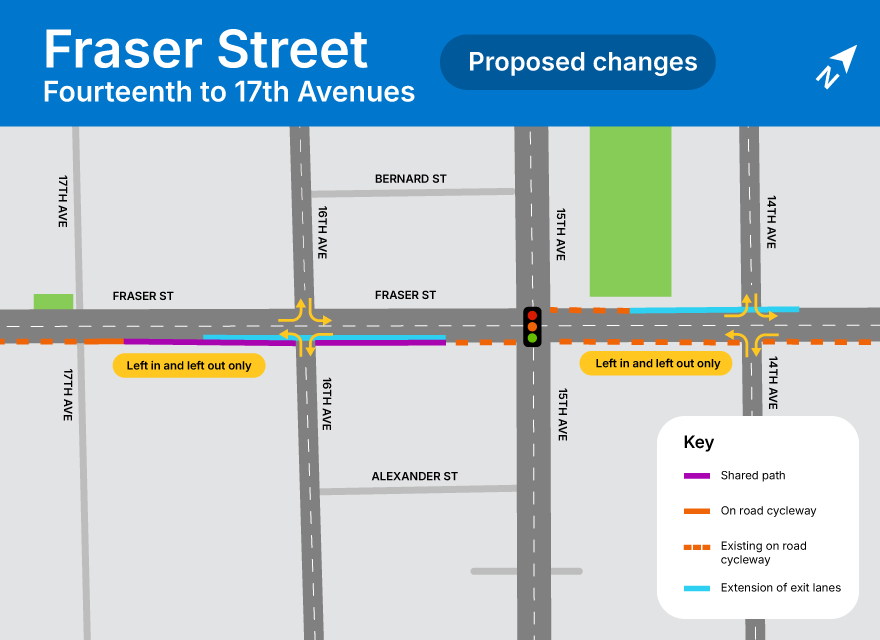
Proposed changes - Fraser Street Fourteenth to 17th Avenues (211kb pdf)
To improve traffic flows across the intersection, we are proposing to extend the exit lanes on Fraser Street, both northbound (north of Fifteenth Ave, toward the city) and southbound (south of Fifteenth Ave, toward Fraser Cove). Extending the exit lanes will involve continuing the current two lanes further along Fraser Street, which will allow more traffic to pass through the intersection during each phase of the lights.
The two northbound exit lanes would be extended to Fourteenth Avenue while the two southbound exit lanes would be extended to Sixteenth Avenue. This would result in the loss of two car parks between Thirteenth and Fourteenth Avenues and four car parks between Sixteenth and 17th Avenues. There will be a shared path south along Fraser Street, between Fifteenth and 17th Avenues.
The intersections at Fourteenth Avenue and Sixteenth Avenue have already been identified as high safety risk intersections. With an additional lane of traffic passing Fourteenth and Sixteenth Avenues, for safety purposes it is proposed to make both Fourteenth and Sixteenth Avenues ‘left in / left out' intersections. This means you would no longer be able to turn across the traffic on Fraser Street. This will have the effect of reducing congestion for vehicles travelling north and south along Fraser Street.