The Pāpāmoa East/Wairākei Interchange opened to traffic in early April 2026. The bridge at Pāpāmoa East, just west of the Kaituna river, was delivered in collaboration with the NZ Transport Agency (NZTA) and built by HEB Construction Ltd.
It connects neighbourhoods in Pāpāmoa to the Tauranga Eastern Link Toll Road / State Highway 2 and is designed to enable faster, more direct travel for the Pāpāmoa community, ease congestion on local feeder roads and future-proof the roading network for planned development in the area.
Prior to opening, the interchange was renamed the ‘Wairākei Interchange’ in reference to the urban growth area of the same name located here, and referencing the historic significance of the area’s wetlands and the Wairākei stream that runs the length of Pāpāmoa.
This project was completed early and under budget.
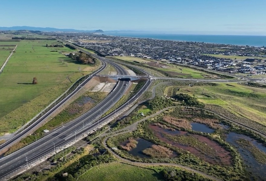
An aerial view of the Wairākei Interchange looking east, with the nature walk around wetland Horoipia in the foreground.
Wairākei Interchange - project journey and cultural artworks
The interchange was completed and opened to the community before Easter 2026. To see the project come to life, including community benefits key milestones and an introduction of the cultural artworks included in the project, watch our project video here.
Pāpāmoa East Interchange -background
Tauranga is growing and changing fast. The Pāpāmoa area is expected to grow significantly over the next decades, increasing to around 40,000 by 2043. Supporting this growth means a need for additional infrastructure, including transport options.
We are committed to developing ‘liveable communities’ that ensure people are optimally connected to the places they live, learn, work and play.
To unlock development at Pāpāmoa East and allow further growth at Golden Sands and Wairākei, the new interchange was built at the eastern end of Te Okuroa Drive, to provide direct access to the motorway.
This interchange enables faster travel between neighbourhoods in Pāpāmoa East and Tauranga City Centre, Mount Maunganui and other destinations for people choosing to travel by car. It will also provide a more direct connection to the Rangiuru Business Park once that is operational.
Why is this important?
Over the past few years, development in Pāpāmoa East has increased pressure on Tara Road and Te Okuroa Drive as the main connections to SH2. The new interchange provides residents in the area with an essential alternative route and enables additional continued development in this area. Pāpāmoa East includes both the Wairākei and Te Tumu areas, which are identified in the SmartGrowth strategy as priority development areas to provide a significant proportion of Tauranga City’s current residential growth demands.
The Wairākei Urban Growth Area is a greenfield development which includes the Golden Sands Town Centre and surrounding residential communities. The Te Tumu Urban Growth Area, currently in the planning stage, is bordered by the Kaituna River and the Wairākei Stream (formerly known as the Pāpāmoa Main Drain, the stream had its original name of Wairākei Stream reinstated in 2004.
Cultural artworks at the interchange
As part of the interchange construction, a number of cultural artworks were installed on and near the bridge. Flanking access to the bridge from Pāpāmoa are two 5-metre tall pou. The pou are Rau Huia – huia feathers – representing chieftainship, mana and stature. Each pou has two unique carvings at it’s centre; these represent paramount chiefs for each of the four local iwi; Tapuika, Waitaha, Ngā Pōtiki and Ngāti Whakaue ki Maketū.
In the evenings, the tip of the feathers is lit with changing colours to invoke the land, water, sky and spirit. Additionally, cultural designs are used on aspects of the bridge itself, on bridge barriers and concrete abutment panels.
These artworks are the work of Te Toi Takapū collective, a local group or traditional Māori carvers/artists. You can find a description of the cultural artworks and their significance on interpretation panels alongside the shared path at the eastern side of the bridge.
Take a closer look at the artworks and discover the story, the artists and the cultural significance behind the designs.